A trio of bighorn lambs use their specialized hoof structure to defy gravity, playing and chasing each other across a sheer cliff above the Highwood River in the central part of the study area. Bighorn lamb mortality is often extremely high for years to decades after a respiratory disease outbreak as surviving adults often become "persistent shedders", passing M.ovi to lambs, who spread it to other young animals during gregarious play. Photo: I. Gazeley
Methods
Study Area
The study area encompassed the eastern slopes of the Rocky Mountains in southern Alberta, from the boundary of Waterton Lakes National Park, north 240 km to the Trans-Canada highway and the south and east borders of Banff National Park, approximately 120 km west of Calgary (Figure 1). The study area lies within the Rocky Mountain Natural Region Alpine, Subalpine and Montane subregions. High elevation areas consist of bare rock, alpine vegetation with heath and graminoid communities, with pockets of dwarf shrubs (Salix sp. and Betula pumila) on more developed soils and northern aspects. At medium elevations a general rain-shadow pattern begins and intensifies eastward through the region, with frequent Chinook winds keeping south and west facing grasslands snow-free for much of the winter, with stands of Engelmann’s spruce (Picea englemannii) and Subalpine fir (Abies lasiocarpa) on north and east aspects. This pattern carries through to lower elevations: south and west facing slopes dominated by grasses, notably Fescue species (Festuca sp.) critically important as winter forage for grazing ungulates, and north and east facing areas with various density coniferous forests. Dense stands of Engelman’s spruce give way to more open stands of White spruce (P. glauca) and Douglas fir (Pseudotsuga menzizii) as elevations decrease. Lower elevations are a mix of spruce and lodgepole pine (Pinus contorta) forests, aspen patches, south aspect grasslands and riparian vegetation (Downing and Pettapiece 2006).
The study area encompassed the eastern slopes of the Rocky Mountains in southern Alberta, from the boundary of Waterton Lakes National Park, north 240 km to the Trans-Canada highway and the south and east borders of Banff National Park, approximately 120 km west of Calgary (Figure 1). The study area lies within the Rocky Mountain Natural Region Alpine, Subalpine and Montane subregions. High elevation areas consist of bare rock, alpine vegetation with heath and graminoid communities, with pockets of dwarf shrubs (Salix sp. and Betula pumila) on more developed soils and northern aspects. At medium elevations a general rain-shadow pattern begins and intensifies eastward through the region, with frequent Chinook winds keeping south and west facing grasslands snow-free for much of the winter, with stands of Engelmann’s spruce (Picea englemannii) and Subalpine fir (Abies lasiocarpa) on north and east aspects. This pattern carries through to lower elevations: south and west facing slopes dominated by grasses, notably Fescue species (Festuca sp.) critically important as winter forage for grazing ungulates, and north and east facing areas with various density coniferous forests. Dense stands of Engelman’s spruce give way to more open stands of White spruce (P. glauca) and Douglas fir (Pseudotsuga menzizii) as elevations decrease. Lower elevations are a mix of spruce and lodgepole pine (Pinus contorta) forests, aspen patches, south aspect grasslands and riparian vegetation (Downing and Pettapiece 2006).
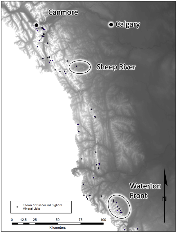
Figure 1. Study area in south west Alberta, Canada showing locations of mineral lick sites known, or suspected, to be used by bighorn sheep.
Study species
Rocky Mountain bighorn sheep (BISH) are the largest of four extant subspecies in North America, the others being the Desert bighorn (O. c. nelsoni), California bighorn (O. c. californiana) and a distinct population Sierra-Nevada bighorn (O. c. sierrae) (Cowan 1940; Buchalski et al. 2016). Wild sheep are sexually dimorphic with mature BISH rams up to double the weight of ewes (Blood, Flook and Wishart) , with horns much larger than those of females. Rocky Mountain bighorn sheep are alpine and subalpine specialists, mostly occurring at high elevations in or near rugged terrain that allows escape from predators, though some populations occur in foothill and prairie environments where adequate escape terrain is available (Geist 1971).
BISH occur widely throughout the study area, primarily at moderate to high elevations during summer months, and within discrete southwest aspect ranges in winter, both at lower and higher elevations. The area is able to sustain approximately 1600 bighorn sheep in numerous subpopulations with various connectivity (Deakin et al. 2020). A relatively large population occurs at low elevation for much of the year along the Sheep and Highwood Rivers, southwest of Calgary. The Sheep/Highwood population is highly connected to other herds within Kananaskis Country to the west; a ~4200 km2 aggregation of Wildland and Provincial Parks running from the Highwood River northwest to Banff. A number of historic respiratory disease outbreaks have occurred among bighorn populations within the study area (Onderka and Wishart 1984), with the most recent die-offs in 1995 in the Waterton Front - South Castle, and a confirmed M.ovi outbreak February / March of 2023 in the Sheep River herd (Figure 1; A. Hubbs and C. Johnson pers.comm. 2022).
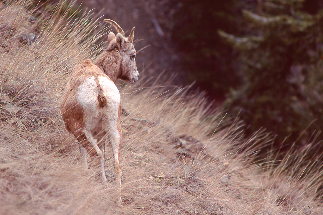
Bighorn ewes often head to higher elevations in late spring, well above the "green wave" of new vegetation growth, returning to lower elevations only after giving birth, and the lamb grows strong enough to escape predators. Photo: I. Gazeley
Mineral lick data
Mineral licks are found sporadically throughout the study area (Figure 1.) and are categorized into three main types: dry-earth, muck, and rock-face licks (Dormaar and Walker 1996; Figure 2.). Muck licks are more visible than other types, and are attractive to deer, elk and moose, with some use by mountain goat and bighorn sheep (Poole et al 2010, Jokinen et al 2014). Dry-earth and rock-face licks appear to be the most visited licks by goats and bighorn sheep, however, these types of licks present a challenge to identify as dry-earth licks often occur in middle elevation forested areas where direct observation is difficult, while rock-face licks often occur above treeline in areas with terrain that may not show trails from frequent use (Cowan and Brink 1949; Poole et al. 2010; Jokinen et al. 2014). Almost all known mineral licks were located through direct observation, with luck being a major factor. A search of the Alberta’s Fish & Wildlife Information Management System (FWMIS) identified 179 "known" or suspected mineral licks located within the study area. Unfortunately, most of the historically documented mineral licks had no associated species-use information [n=111]. Of the mineral licks with "known" species use, 42 were considered suspected or confirmed bighorn sheep sites (Figure 1.).
Mineral licks are found sporadically throughout the study area (Figure 1.) and are categorized into three main types: dry-earth, muck, and rock-face licks (Dormaar and Walker 1996; Figure 2.). Muck licks are more visible than other types, and are attractive to deer, elk and moose, with some use by mountain goat and bighorn sheep (Poole et al 2010, Jokinen et al 2014). Dry-earth and rock-face licks appear to be the most visited licks by goats and bighorn sheep, however, these types of licks present a challenge to identify as dry-earth licks often occur in middle elevation forested areas where direct observation is difficult, while rock-face licks often occur above treeline in areas with terrain that may not show trails from frequent use (Cowan and Brink 1949; Poole et al. 2010; Jokinen et al. 2014). Almost all known mineral licks were located through direct observation, with luck being a major factor. A search of the Alberta’s Fish & Wildlife Information Management System (FWMIS) identified 179 "known" or suspected mineral licks located within the study area. Unfortunately, most of the historically documented mineral licks had no associated species-use information [n=111]. Of the mineral licks with "known" species use, 42 were considered suspected or confirmed bighorn sheep sites (Figure 1.).
 Figure 2. A "rock-face" mineral lick site located at tree-line in the Crowsnest Pass region of the study area. The author identified this site by observing dense fecal deposition among the jagged rocks at its base, unlikely to be used as a bedding area. Remote cameras will be deployed at this site and other suspected lick locations identified in this study, in early 2023. Photo: I. Gazeley
Animal Movement Data
Temporally explicit spatial data was acquired between April 1, 2022 and February 8, 2023 from 35 bighorn rams collared in early, 2022 as part of the author's research on bighorn ram movement ecology and disease risk. Collaring occurred by aerial net-gun capture, with health sampling, numbered ear and GPS collar attachment (Survey 2D Iridium with rot off and remote release, VECTRONIC Aerospace GmbH) under approved University of Alberta AUP #00004119. Collar parameters were set to collect GPS fixes at 2:00 hour intervals between 5:00 am and 11:00 pm daily (10 fixes / day), producing 100,636 locations.
Temporally explicit spatial data was acquired between April 1, 2022 and February 8, 2023 from 35 bighorn rams collared in early, 2022 as part of the author's research on bighorn ram movement ecology and disease risk. Collaring occurred by aerial net-gun capture, with health sampling, numbered ear and GPS collar attachment (Survey 2D Iridium with rot off and remote release, VECTRONIC Aerospace GmbH) under approved University of Alberta AUP #00004119. Collar parameters were set to collect GPS fixes at 2:00 hour intervals between 5:00 am and 11:00 pm daily (10 fixes / day), producing 100,636 locations.
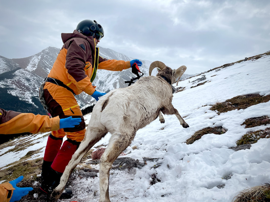
A young three year old bighorn ram is released after capture for disease, health and DNA samping, and being fitted with a GPS telemetry collar that collects location data at two hour intervals for approximately 2.5 years. The movement data collected is being used to improve habitat selection models, document seasonal migrations and population connectivity, and understand foray behaviour. This information is critical in preventing future respiratory disease outbreak related to contact with domestic sheep and goats. Photo: I. Gazeley
Study design
All data used in analyses was prepared using ArcMap (ArcGIS Desktop v. 10.8.2 2021), R (v. 4.2.2) and RStudio (v. 2023.03.0) and Excel (Microsoft Office v. 16.69). Animal movement data collected between April 1, 2022 and February 8, 2023 (n = 104,339 locations) was quality checked by removing locations from animals that did not survive May 1 - Aug. 15, where GPS fixes were made with fewer than four satellites (i.e. not 3D validated), and where the collar recorded elevation was >350 metres different than the spatially associated value extracted from a 25 m raster DEM (0.75 arc-second Canadian Digital Elevation Model; NRCAN 2016), removing any point where the difference was >350 metres. GPS collar data commonly contain erroneous locations due to multipath errors, common in rugged mountainous terrain and where dense vegetation occurs.
Movement parameters
Movement parameters were calculated in the R package adehabitatLT (v. 0.3.27; Calenge 2005-2023) including the euclidean distance between locations ('dist' in metres), and the relative change in angle ('turn' in absolute radians) between points a-b and b-c. The distance of each movement location ('gps_data') was calculated to the nearest "known" mineral lick site ('lick_sites') using the following expression (for 'nearest_lick'): gps_data$nearest_lick <- apply(gps_data[, c("x", "y")], 1, function(coord) {min(sqrt((lick_sites$x - cood[1])^2 + (lick_sites$y - coord[2])^2))}). These three derived parameters, 'dist', 'turn' and 'nearest_lick', were used in subsequent analyses.
Patterns of movement
Visual inspection of movement data near a few known (confirmed) BISH mineral licks (Figure 3.) suggested a pattern of use where the angle of the movement path in and out of the lick site was high, and visits mostly occurred between 9 am and 7 pm. Bighorn sheep are known to frequent mineral licks as early as mid-April through early September, with the the peak period of use in May through mid-August (Hebert and Cowan 1971; Jokinen et al 2014). Using these movement characteristics, multiple data sets were created to explore differences between lick-use and other movement patterns (Table 1). These data sets included filtered and cleaned data from April 1, 2022 to February 8, 2023, prefix sets (see 'u', 'g', and 't'; Table 1) and various distance thresholds of 125, 250, 500, 750 and 1000 metres, and a "training" subset with points near a small number of confirmed BISH licks, instead of near the many "known" lick sites where use could not be confirmed.

Table 1. Description of data set prefixes, and associated dates and times.
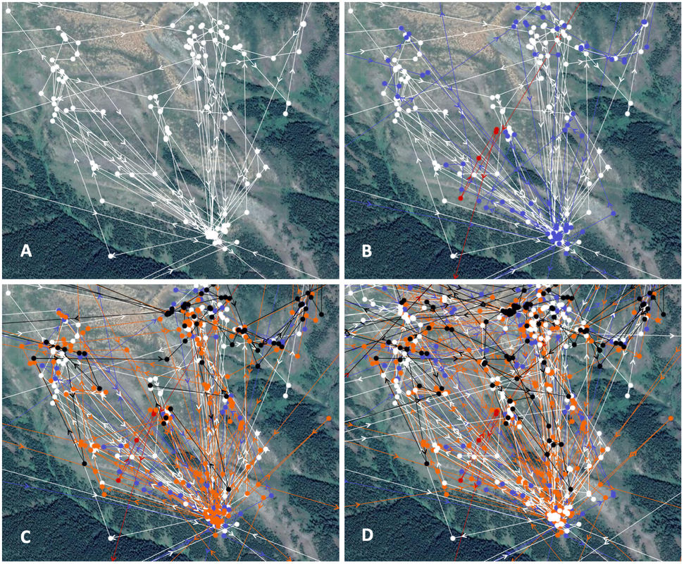
Figure 3. GPS derived movement data at a mineral lick location in the Waterton Front area in southwest Alberta, May 1 - August 15 2022 for (A) an individual bighorn ram, (B) for 3 rams (C) five rams over the same time period, and (D) for five rams between April 1, 2022 and February 8, 2023.
To predict locations likely to be near a mineral lick, Random Forest models were developed from the previously mentioned data sets. Model predictions were made for both the complete data set ('gps_data') and for the MA77 data.
